


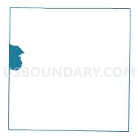
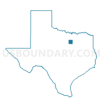
Voting District 4065, Tarrant County, Texas
About
Outline

Summary
| Unique Area Identifier | 677185 |
| Name | Voting District 4065 |
| County | Tarrant County |
| State | Texas |
| Area (square miles) | 16.61 |
| Land Area (square miles) | 16.49 |
| Water Area (square miles) | 0.12 |
| % of Land Area | 99.31 |
| % of Water Area | 0.69 |
| Latitude of the Internal Point | 32.81104390 |
| Longtitude of the Internal Point | -97.53168330 |
Maps

Graphs
Select a template below for downloading or customizing gragh for Voting District 4065, Tarrant County, Texas


Neighbors
Neighoring Voting District (by Name) Neighboring Voting District on the Map
- Voting District 0100, Parker County, TX
- Voting District 0111, Parker County, TX
- Voting District 0400, Parker County, TX
- Voting District 0415, Parker County, TX
- Voting District 4242, Tarrant County, TX
- Voting District 4259, Tarrant County, TX
- Voting District 4272, Tarrant County, TX
- Voting District 4276, Tarrant County, TX
- Voting District 4284, Tarrant County, TX
- Voting District 4340, Tarrant County, TX
- Voting District 4369, Tarrant County, TX
- Voting District 4373, Tarrant County, TX
Top 10 Neighboring County Subdivision (by Population) Neighboring County Subdivision on the Map
- Fort Worth CCD, Tarrant County, TX (791,745)
- Springtown-Reno CCD, Parker County, TX (37,832)
- Weatherford Southeast CCD, Parker County, TX (27,636)
Top 10 Neighboring Place (by Population) Neighboring Place on the Map
Top 10 Neighboring Unified School District (by Population) Neighboring Unified School District on the Map
- Fort Worth Independent School District, TX (466,910)
- Azle Independent School District, TX (36,509)
- White Settlement Independent School District, TX (31,573)
- Aledo Independent School District, TX (20,504)
Top 10 Neighboring State Legislative District Lower Chamber (by Population) Neighboring State Legislative District Lower Chamber on the Map
Top 10 Neighboring State Legislative District Upper Chamber (by Population) Neighboring State Legislative District Upper Chamber on the Map
- State Senate District 12, TX (1,013,641)
- State Senate District 10, TX (834,265)
- State Senate District 30, TX (823,594)
Top 10 Neighboring 111th Congressional District (by Population) Neighboring 111th Congressional District on the Map
Top 10 Neighboring Census Tract (by Population) Neighboring Census Tract on the Map
- Census Tract 1404.07, Parker County, TX (10,214)
- Census Tract 1407.06, Parker County, TX (6,557)
- Census Tract 1142.07, Tarrant County, TX (5,931)
- Census Tract 1108.06, Tarrant County, TX (4,580)
- Census Tract 1142.06, Tarrant County, TX (4,468)
- Census Tract 1404.08, Parker County, TX (4,270)
- Census Tract 1142.05, Tarrant County, TX (3,106)
- Census Tract 1006.01, Tarrant County, TX (2,027)